
Event format
The WMOC Sprint competition consists of one Qualification race and a Final race. The WMOC Forest competitions consist of one Qualification race, a Middle Final race and a Long Final race. Qualifiers for each Final will be determined in accordance with IOF Competition Rules (2021). Details will be published in Bulletin 2 and on https://wmoc2021.hu
Winning times
(in accordance with the IOF FootO Competition Rules)
| Class | SQ+SF | FQ | MF | LF | Born |
| M35 | 12-15 | 50 | 30-35 | 70 | -1986 |
| M40 | 12-15 | 50 | 30-35 | 65 | -1981 |
| M45 | 12-15 | 45 | 25-30 | 60 | -1976 |
| M50 | 12-15 | 45 | 25-30 | 55 | -1971 |
| M55 | 12-15 | 40 | 25-30 | 50 | -1966 |
| M60 | 12-15 | 40 | 25-30 | 50 | -1961 |
| M65 | 12-15 | 40 | 25-30 | 50 | -1956 |
| M70 | 12-15 | 40 | 25-30 | 50 | -1951 |
| M75 | 12-15 | 40 | 25-30 | 50 | -1946 |
| M80 | 12-15 | 40 | 25-30 | 50 | -1941 |
| M85 | 12-15 | 40 | 25-30 | 50 | -1936 |
| M90 | 12-15 | 40 | 25-30 | 50 | -1931 |
| M95 | 12-15 | 40 | 25-30 | 50 | -1926 |
| M100 | 12-15 | 40 | 25-30 | 50 | -1921 |
| Class | SQ+SF | FQ | MF | LF | Born |
| W35 | 12-15 | 40 | 30-35 | 55 | -1986 |
| W40 | 12-15 | 40 | 30-35 | 50 | -1981 |
| W45 | 12-15 | 35 | 25-30 | 45 | -1976 |
| W50 | 12-15 | 35 | 25-30 | 45 | -1971 |
| W55 | 12-15 | 35 | 25-30 | 45 | -1966 |
| W60 | 12-15 | 35 | 25-30 | 45 | -1961 |
| W65 | 12-15 | 35 | 25-30 | 45 | -1956 |
| W70 | 12-15 | 35 | 25-30 | 45 | -1951 |
| W75 | 12-15 | 35 | 25-30 | 45 | -1946 |
| W80 | 12-15 | 35 | 25-30 | 45 | -1941 |
| W85 | 12-15 | 35 | 25-30 | 45 | -1936 |
| W90 | 12-15 | 35 | 25-30 | 45 | -1931 |
| W95 | 12-15 | 35 | 25-30 | 45 | -1926 |
| W100 | 12-15 | 35 | 25-30 | 45 | -1921 |
SQ = Sprint Qualification – winning time in minutes
SF = Sprint Final – winning time in minutes
FQ = Forest Qualification – winning time in minutes
MF = Middle Final – winning time in minutes
LF = Long Final – winning time in minutes
Born = in order to participate, the athlete must be born in the year indicated or earlier.
Terrain description and maps
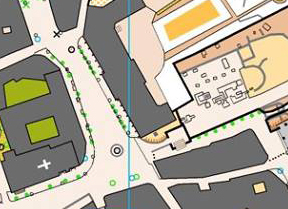
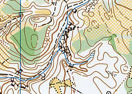
Sprint Qualification race – Budaörs
30% park and 70% urban terrain with housing estate buildings and residential houses, small shopping centres, parks and schools. Building patterns are irregular and courtyards of schools, sport grounds, etc. provide good orienteering challenge. There will be some climb in the courses. Little traffic is expected.
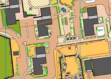

Map: ISSprOM 2019 standard, scale 1:4.000 / 1:3.000, contour interval 2,5 m. Old map from 2018 available from https://wmoc2021.hu. New survey in February 2021, updates July 2021.
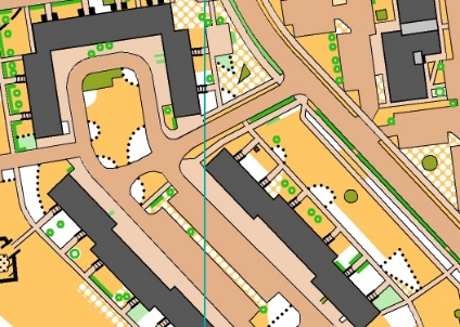
Sprint Final race – Székesfehérvár
Downtown area of the old Hungarian coronation city with 10% park and 90% urban terrain. Typical old town area with smaller and bigger passages, little parks and some residential areas. Some of the courtyards are expected to be opened for the WMOC Sprint Final. Building patterns are irregular. The area has very little elevation difference. Roads inside the area will be closed, but minor traffic and walkers are expected in the complex downtown area.
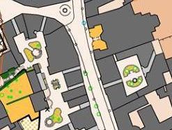

Map: ISSprOM 2019 standard, scale 1:4.000 / 1:3.000, contour interval 2.5 m. Old map from 2015 available from https://wmoc2021.hu. New survey in February 2021, updates July 2021.
Forest Qualification race – Pákozd
This is a moderately hilly area between 150-240 m asl with many erosion features (spurs and re-entrants), small hills and man-made pits. Mostly oak forest, partly open areas with irregular thickets and bushes. There is some ground vegetation in the forested areas. There are some andesite boulders, mostly 1 to 2 metres, but a couple are as large as 10 metres. Open areas have hard granite surface. Firm ground, no marshes. Runnability and visibility is limited in the forest part and excellent in the open areas. Moderate track density.


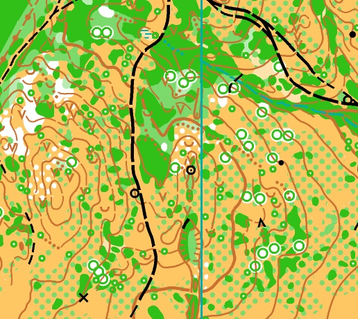

Map: ISOM 2017-2 standard, scale 1:10.000 / 1:7.500, contour interval 5 m. An old FootO map from 1991 and an old MTBO map from 2019 are available from https://wmoc2021.hu. New survey in March-August 2020, updates May 2021.
Middle Final race – Pákozd
This is a moderately hilly area between 150-240 m asl with many erosion features (spurs and small re-entrants) and man-made pits. Most of the area is on a slope, where getting the elevation right will be essential. Mostly open areas with irregular thickets and bushes with some green forest between the open areas. The longer courses will also visit some forested areas (oak). There is some ground vegetation in the forested areas, but none in the open areas. There are some andesite boulders, mostly 1 to 2 metres high. Open areas have hard granite surface. Firm ground, no marshes. Runnability is excellent in most places, but limited in the green / forested areas. Varying visibility, even in the open areas (because of the thickets). Lowtrack density.


Map: ISOM 2017-2 standard, scale 1:10.000 / 1:7.500, contour interval 5 m. An old FootO map from 1991 and an old MTBO map from 2019 are available from https://wmoc2021.hu. New survey in March-August 2020, updates May 2021.
Long Final race – Lovasberény
This is a hilly area between 200-350 m asl. The steeper parts are located farther away from the arena. The terrain was partly formed by erosion, the valleys are deeper in the hilly areas. There are also small hills and some man-made pits in the terrain. Vegetation is oak forest withdifferent shades of green and some open parts, but the forested area is dominant. Some ground vegetation. There are many andesite boulders, 1 to 3 metres high, in one part of the terrain. Steep valley sides feature rocks and cliffs, but most of the terrain is not rocky. Firm ground, no marshes. Runnability is mostly limited, ideal for route-choice orienteering. The area close to the finish has particularly good runnability. Visibility is mostly limited. Visibility is better in the steep hillsides and close to the finish area. Average track density.

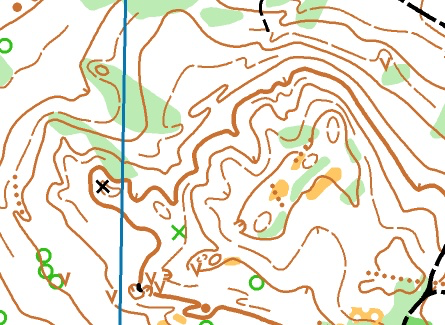


Map: ISOM 2017-2 standard, scale 1:10.000 / 1:7.500, contour interval 5 m. An old FootO map from 1996 and 1998 and an old MTBO map from 2019 are available from https://wmoc2021.hu. New survey in March-August 2020, updates May 2021.